


- Explore top picks on African tours & safaris
- Including Kruger, Serengeti, Masai Mara & Victoria Falls
- Filter tours by price, type, travellers, duration & more
Malawi weather by month
Check out Malawi weather averages by month. Compare detailed monthly climate statistics including temperature, rainfall and sunshine figures.
| Jan | Feb | Mar | Apr | May | Jun | Jul | Aug | Sep | Oct | Nov | Dec | |
|---|---|---|---|---|---|---|---|---|---|---|---|---|
| Maximum daytime temperature °C |  27 27 |
27 |
27 |
27 |
26 |
 24 24 |
24 |
25 |
 28 28 |
 30 30 |
30 |
28 |
| Hours of sunshine (daily) | ||||||||||||
| Days with some rainfall |  18 18 |
 15 15 |
 12 12 |
 6 6 |
 2 2 |
1 |
1 |
1 |
1 |
2 |
 7 7 |
16 |
More about Malawi
Malawi by month
Jan Feb Mar Apr May Jun Jul Aug Sep Oct Nov Dec
Recommended for Malawi
The climate guide for Malawi (Lilongwe) shows long term monthly weather averages processed from data supplied by CRU (University of East Anglia), the Met Office & the Netherlands Meteorological Institute. Find out more about our data sources.
Malawi climate overview
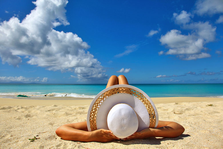
Malawi is an elevated landlocked country in south-eastern Africa to the north of Mozambique and to the east of Zambia. Known formerly as Nyasaland this ex-British colony was explored by David Livingstone in the nineteenth century who dubbed Lake Nyasa the 'Lake of Stars' for of its crystal clear waters.
The dominant physical feature is the long and narrow lake, now known as Lake Malawi, a huge highland body of freshwater and the most southerly lake in the Great Rift Valley. It is fringed by sandy beaches, enclosed by sheer mountains covered in tropical vegetation, though much of the original woodland has been cleared for cultivation.
Northern Malawi consists of the rolling Nyika and Viphya Plateaux, which are covered in montane grassland and damp bog, beautified by wildflowers. Rugged escarpments and mountains rise from the plateaux, with slopes either clad in thick forests or cleared to grow tea and tobacco.
The climate in Northern Malawi is characterised by a long wet season running from November to April when cloudiness is greatest and there are frequent thunderstorms. Temperatures are warm with occasional hot days confined to October and November, just before the rains arrive. The cooler season from May to October is mostly dry and much sunnier with comfortable daytime temperatures.
Southern Malawi is more densely populated than the north and is mostly low-lying except for the Zomba Plateau and the huge, isolated Mulanje Massif in the southeast. A river valley runs from the southern end of Lake Malawi through a number of game reserves, and eventually into neighbouring Mozambique. The valley is dominated by wetlands and grassland supporting grazing cattle.
In the south the rainy season is usually slightly shorter than in the north, although rainfall everywhere in Malawi can be variable. Temperatures throughout the lowlands are a few degrees hotter than on the northern plateaux and high heat and humidity can be a problem in the wet season.
Top Malawi destinations
Below are average maximum temperatures at popular countries, regions and places in Malawi for next month - June. Select a destination to see the climate guide for all months of the year.

All Malawi destinations
Malawi weather averages
Temperature in Malawi (°C)
| Jan | Feb | Mar | Apr | May | Jun | Jul | Aug | Sep | Oct | Nov | Dec | |
|---|---|---|---|---|---|---|---|---|---|---|---|---|
| Max temperature (daytime) | 27 |
27 |
27 |
27 |
26 |
24 |
24 |
25 |
28 |
30 |
30 |
28 |
| Min temperature (night-time) |  18 18 |
18 |
 17 17 |
15 |
 12 12 |
 9 9 |
9 |
10 |
13 |
16 |
18 |
18 |
| Heat & Humidity |  M M |
M |
 L L |
L |
 0 0 |
0 |
0 |
0 |
L |
M |
M |
M |
Note: 0 = None, L = Low, M = Moderate, H = High, VH = Very high, E = Extreme
Sunshine & UV index in Malawi
| Jan | Feb | Mar | Apr | May | Jun | Jul | Aug | Sep | Oct | Nov | Dec | |
|---|---|---|---|---|---|---|---|---|---|---|---|---|
| Daily hours of sunshine | ||||||||||||
| Daily hours of daylight |  13 13 |
13 |
 12 12 |
12 |
 11 11 |
11 |
11 |
12 |
12 |
12 |
13 |
13 |
| UV Index (Maximum) |  11 11 |
11 |
11 |
 11 11 |
 9 9 |
8 |
9 |
10 |
11 |
11 |
11 |
11 |
Rainfall in Malawi
| Jan | Feb | Mar | Apr | May | Jun | Jul | Aug | Sep | Oct | Nov | Dec | |
|---|---|---|---|---|---|---|---|---|---|---|---|---|
| Number of days with some rain | 18 |
15 |
12 |
6 |
2 |
1 |
1 |
1 |
1 |
2 |
7 |
16 |
| Average monthly rainfall (mm) |  223 223 |
 188 188 |
 129 129 |
 45 45 |
 9 9 |
1 |
1 |
 0 0 |
1 |
8 |
59 |
 179 179 |
Compare Malawi weather with the UK
The weather chart below compares the average monthly maximum daytime temperature for Malawi (Lilongwe) and the UK (London).
Maximum daytime temperature (°C)
Malawi (Lilongwe)
UK (London)
Jan
Feb
Mar
Apr
May
Jun
Jul
Aug
Sep
Oct
Nov
Dec
Metric (°C / mm) | Imperial (°F / inches)
Be inspired
Get your weekly fix of holiday inspiration from some of the world's best travel writers plus save on your next trip with the latest exclusive offers
We promise not to share your details
Related posts

Popular travel offers


Explore holiday destinations
- Beach holidays
- City breaks
- Family holidays
- Half term holidays
- Spring holidays
- Summer holidays
- Autumn holidays
- Winter sun holidays
- Honeymoons
- Coolcations
- Compare places
- Ski resorts
Save with latest deals & discounts
- Holiday offers
- Top travel brands
- Airlines & flights
- Discount hotels
- TUI
- Jet2holidays
- Neilson
- Marella Cruises
- Holiday Extras
- Pierre & Vacances
- Caledonian Travel
- Club Med
Airport parking
- Manchester Airport
- Stansted Airport
- Bristol Airport
- Luton Airport
- Birmingham Airport
- Edinburgh Airport
- Gatwick Airport
- Glasgow Airport
- Newcastle Airport
Airport lounges
- Manchester Airport
- Birmingham Airport
- Bristol Airport
- Edinburgh Airport
- Glasgow Airport
- Heathrow Airport
- Newcastle Airport
- Stansted Airport
- Gatwick Airport